A Comparison of Stereo and Multiview 3D Reconstruction Using Cross-sensor Satellite Imagery
- AuthorsOzge C. Ozcanli, Yi Dong, Joseph L. Mundy
- Date04 February 2016
- SourceInternational Journal of Computer Vision (IJCV), Volume 116, Issue 3, pp 226-246
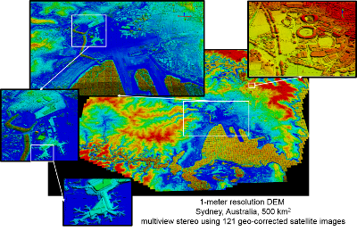
In this paper, an automatic geo-location correction framework that corrects multiple satellite images simultaneously is presented. As a result of the proposed correction process, all the images are effectively registered to the same absolute geodetic coordinate frame. The usability and the quality of the correction framework are shown through probabilistic 3D surface model reconstruction. The models given by original satellite geo-positioning meta-data and the corrected meta-data are compared and the quality difference is measured through an entropy-based metric applied onto the high resolution height maps given by the 3D models.