SatTel: A Framework for Commercial Satellite Imagery Exploitation
- AuthorsAndrew D. Gilliam, Thomas B. Pollard, Andrew Neff, Yi Dong, Scott Sorensen, Robert Wagner, Selene Chew, Todd V. Rovito, Joseph L. Mundy
- Date12 March 2018
- Source2018 IEEE Winter Conference on Applications of Computer Vision (WACV)
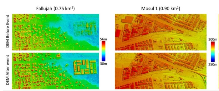
This paper presents the innovative SatTel framework, designed to automatically access, collate, process, and exploit commercial satellite imagery from a wide variety of vendors. Established vendors such as DigitalGlobe provide high resolution imagery with limited coverage, while disruptive vendors such as Planet and BlackSky provide low resolution imagery with near global coverage. SatTel provides a single point of entry for exploitation of these contrasting and complementary vendor capabilities. The authors illustrate the value of the SatTel framework via demonstrative change detection capabilities. SatTel change detection from small satellite imagery based on comparison of image to image appearance achieves mean average precision (MAP) above 0.75 for many sites compared to ground truth analyst annotation. SatTel change detection from high resolution satellite imagery based on multidimensional geometric structures achieves an average precision of 0.84 for elevation changes above 3.0 meters compared to ground truth analyst annotation.